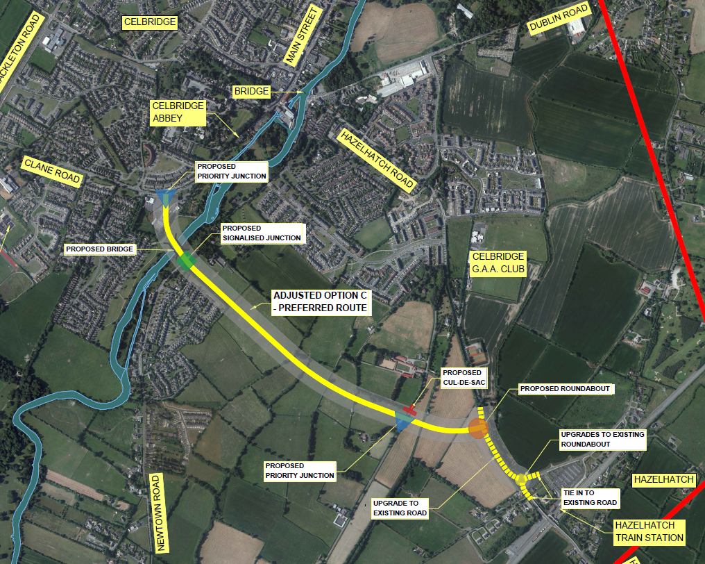
A new vehicular bridge across the Liffey, to alleviate traffic congestion over the existing vehicular bridge.
Another objective is to enhance active and sustainable travel in Celbridge by (a) improving connectivity to Hazelhatch train station and (b) encouraging pedestrian and cycling modes of travel within the town.
The official Preferred Route Option is as shown in the map, starting at the Texaco filling station on the Clane Road, crossing the Liffey and the Newtown Road north of the Temple Manor and joining the R405 north of the Hazelhatch train station roundabout.

April 2025
From the Chief Executive's Report April 2025:
All documents for the application have been received from consultant and being reviewed prior to submission to An Bord Pleanála.
It would now appear that the review is under way.
March 2025
No change. From the Chief Executive's Report March 2025:
All documents for the application have been received from consultant and will be reviewed internally and by Senior Counsel prior to submission to the Board.
February 2025
No change. From the Chief Executive's Report February 2025:
All documents for the application have been received from consultant and will be reviewed internally and by Senior Counsel prior to submission to the Board.
Discussions in the February meeting of the Celbridge-Leixlip Municipal District suggest a completion date of 2028 or later.
January 2025
Documents received from the consultant in early December. No timeline available for the internal KCC review, due to critical resources allocated to both this project and the Maynooth Eastern Ring Road project. Source: Kildare Now report on the January Celbridge-Leixlip MD meeting.
December 2024
The December 2024 KCC Chief Executive’s Management Report repeats the same message from the October report and then adds the following:
"All documents for the application are due from the consultant in early December and will be reviewed internally and by Senior Counsel prior to submission to the Board."
November 2024
The November 2024 KCC Chief Executive’s Management Report repeats the same message from the October report and then adds the following:
"All documents for the application are due from the consultant later this month and will be reviewed internally and by Senior Counsel prior to submission to the Board."
October 2024
From the October 2024 KCC Chief Executive’s Management Report:
"A joint application to An Bord Pleanála for compulsory purchase of land and consent will be submitted in late 2024."
Note the change in language: there is no mention of this being conditional on the availability of staff.
July 2024
From the minutes of the July 2024 Municipal District Meeting:
"Celbridge Hazelhatch Mobility Corridor Project is currently at the Preliminary Design and Statutory Process stage. It is hoped to submit a joint application to An Bord Pleanála for consent and for the compulsory purchase of land before the end of 2024, however this is subject to the availability of key resources."
Funding for the project appears to be secure, but staff shortages may be delaying progress, as discussed above.
The process through An Bord Pleanála could take a year or more. This would then be followed by further design work, tendering and construction.
June 2024
From the June 2024 KCC Chief Executive’s Management Report:
"It is expected that the Compulsory Purchase Order (CPO) and Planning Consent will be submitted in Q3 2024."
January 2024
From the January 2024 KCC Chief Executive’s Management Report:
"It is expected CPO and Planning Consent will be submitted in Q2 2024"
Is the second bridge going to be built?
The answer here seems to be a definitive "yes". The Government is heavily invested in making DART+ a success and that means encouraging as much usage of Hazelhatch train station as possible. This is why the second bridge has been connected with a Hazelhatch Link Road project, to make it as easy as possible to use the park-and-ride facilities at Hazelhatch train station.
Secondly, a major housing development at Simmonstown has the second vehicular bridge as a precondition, as given in the 2017 Local Area Plan for Celbridge. It should be noted that meeting this precondition does not depend on the location of the second bridge.

Why was a route near the Slip, at the north end of Main Street not selected?
This route was eliminated relatively early on in the route selection process, mainly for heritage reasons:
"In addition, the connection and interrelationship between the historic town of Celbridge and Castletown House and demesne is highly significant. […] Route Options [at the north end of Main Street] will run past the southwestern entrance into [Castletown] demesne in this sensitive part of the town. It will sever the connection to the town and will impact on the collective setting of these structures. It is considered that the historic environment in this location would be incapable of absorbing the development of a link road. […] Given the sensitivity of this area the three easternmost routes [at the north end of Main Street] should not be considered an option from a cultural heritage perspective[…]"
Source: KCC, RPS, "Celbridge to Hazelhatch Link Road: Preliminary Options Assessment Report", pg. 110, March 2022.
Why was a route option to the south of St. Wolstan's Community School and North Kildare Educate Together National School not selected?
While, in the final stage of route selection, these routes had the best potential for reducing trip travel times (pg. 84), they were eliminated mainly due to poorer assessments on environmental impacts, particularly in regards to impacts on flood plains and historical heritage:
"The Liffey crossing location for Options A and A1 [south of St. Wolstan's Community School] are within floodplains that affects a large number of residential properties; therefore these options are the least preferable from a flood risk point of view." (pg.104)
"Though essentially green field, this proposed option would cut into the historic boundary formed by a mature belt of woodland associated with Killadoon House." (pg. 108)
Source for page references: KCC, RPS, "Celbridge to Hazelhatch Link Road: Options Appraisal Report", December 2022.
